


| ||||||||||
| | | | | | | | | | |
Western massif of the Picos de Europa (El Cornion, Asturias, Spain)
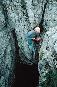
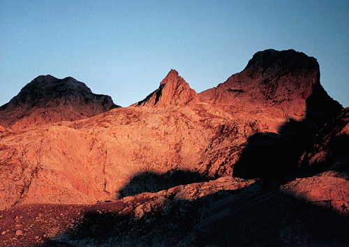
The systematic exploration of this massif has already continued for three decades. The authorities of the Picos de Europa National Park, acting through the Federación Asturiana de Espeleología, have allotted Poles, coming to this area since 1978, an extensive area in the Asturian part of the massif. The boundary of this area is a line 10.1 km long, running through the Torre de la Canal Parda - Torre los Traviesos - Tiro la Llera - Torre de los Cabrones - Punta Gregoriana - Pica de la Jorcada - Pico Conjuarto - Porru Curenes - Sierra Robecas - Contolimpou - Porra la Altiquera - Camino de los Barrastrosas - Pico de los Asturianos. The area includes northern slopes of the Torre Santa María and Torre de los Traviesos, and measures 4.5 km2. The highest point in the area is the summit of the Torre de los Traviesos with altitude of 2,385 m, and the lowest is the bottom of the cirque Joos de Reseco at ca. 1450 m of altitude.
It happened that a systematic exploration was done by another club in each decade. The history of exploration since the early 70ties till 1996 was published in the special issue of Jaskinie, published for the 12th International Speleological Congress. Let us recall: The 70ties was the time when French cavers from Speleo Club Orsay de Faculte (SCOF) performed systematic work in 1972-1976. The deepest caves explored during this period include:
The members of SCOF have discovered about 50 caves. At the same time they started exploring in another massif, the Ozania, which they deemed more promising. As a result, their activity in this area was abandoned. The first Polish reconnaissance trip was in 1978, but only a year later members of Speleoklub Gliwice (SG) began a planned exploration, continued till 1989. The main achievements at that time were:
A new club appears with the new decade. Speleoclub Wrocław (SCW) has been exploring since 1991. The following discoveries have been done in 1996:
Water was dyed at the bottom of Sistema del Jou de la Canal Parda, but the tracer has been not found in the Rio Redemuna, where it was expected. After finishing exploration in Sistema del Jou de la Canal Parda, intense prospecting began for a new big exploration target.
Zone G was selected for prospecting in 1997. The main goal of the expedition was exploration of the deepest cave in the zone - G-13. Its entrance at altitude 2074 m was found by an expedition of Speleoklub Gliwice in 1988. Exploration was begun a year later by an expedition of Sekcja Grotołazów Klubu Wysokogórskiego Wrocław. The expedition terminated unexpectedly because of an accident at the depth of 429 m. The unfinished exploration left some expectations for continuation. However, no possibility of continuation was found at the bottom. Two side series were found and negatively explored: from ca -270 m to ca -350 m and from ca -170 m to -230 m. The cave was considered unpromising for further exploration. Surface prospecting was done in zone G and near Jou de la Canal Parda, Jou de Arenizas and Jorcada Blanca. Despite searching many earlier known and newly discovered entrances, no significant depths were achieved. The area of prospecting was extended in 1998. In zone G, caves discovered in the 70ties by SCOF on the slopes of the La Asunciana were explored. G-1 (-190) was communicated with the small G-6 and possibly with Red de los Barrastrosas (G-7/G-4/G-5; - 315 m). The higher lying entrance G-1 raised the total depth of the system to 322 m. Exploration in the Red de los Barrastrosas did not bring remarkable results.
Zone A also revisited was. Little progress was made in the exploration in Pozu del Porru la Capilla (A-11; -863 m) in a series at ca -250 m and in caves on the NW slopes of the Torre de los Traviesos. Exploration was also attempted in Pozu de los Garapozales (A-3), explored by SCOF probably to ca -60 m. The depth of 432 m was reached at the bottom of a nearly 100 m deep shaft choked with fallen rocks.
Dye-tracing was the main activity in 1999. The aim was to study the drainage of Sistema del Jou de la Canal Parda (A-30/A-25/A-24/A-1; -903 m, that is 1312 m above sea level), Pozu del Porru de la Capilla (A-11; -863 m, that is 1285 m a.s.l.), Sistema Conjuarto (1/6, 2/6; -658, that is 1341 m a.s.l.; in the zone of the Oxford University Cave Club) and Sistema del Canalon de los Desvios (F-18/F-17/F-15; -542 that is 1312 m a.s.l.). The final, drowned series of these caves lie beneath the cirque Joon de los Desvios, where waters drained by these systems may join and be drained farther. Pozu del Porru la Capilla (A-11; -863 m) was selected for the experiment. The outflow was expected in the Río Junjumia, Río Redemuna and Río Casano. The positive result was obtained only in the Río Redemuna.
After the dying, exploration was attempted in Pozu del Porru la Capilla (A-11; -863 m). The entrance at altitude 2148 m was discovered by an expedition of Speleoklub Gliwice (SG) in 1984. Exploration was then ended by a tragedy at ca -180 m. Two years later the cave was explored to ca -400 m by an expedition of Sekcja Taternictwa Jaskiniowego Częstochowa (STJC). The final lake at - 863 m was reached in 1987 and the cave has been not explored. One of the most interesting places in this cave was the final lake. However, attempts at exploration proved unsuccessful. Similarly ended exploration of other high-lying entrances in zone A.
Dye tracing was done also in 2000, this time in zone G. The only, though not a good one, object for dying was G-13, 429 m deep (ca 250 m above the expected base of erosion at Gueros de Junjumia). The Río Junjumia, Río Redemuna and Río Beyera were selected for observation. The appearance of the tracer, however, has been not confirmed in any of the streams. Despite the earlier negative opinion, an exploration reconnaissance was attempted in the final chamber of G-13 already during the preparation for dying. After the dying, further action was undertaken, though at no avail. A few alternative entries were found into the boulder chock at the bottom of the chamber, but none of them was pushed for more than twenty metres. Possibilities above the chamber were also tried with a negative result. This cave, unfortunately, has to be considered as lacking prospects for exploration.
A renewed attempt at exploration was made in Pozu del Porru de los Garapozales (A-3; -432 m). The exploration goal in this cave was to bypass the final hundred-metres shaft. After a traverse above the shaft a possibility of descent appeared. However, despite of using long HSA anchors, we could not rig for a safe descent. Because of the high risk, exploration was abandoned.
In zone F, exploration was made in Sima de los Desvios (F-3; -323 m). The main goal was to resurvey it and make an exploration reconnaissance. For the lack of any leads, no exploration was undertaken. Exploration behind a nearby entrance (F-3B) resulted in communication with the main series at ca -70 m.
Reconnaissance was continued in Red de los Barrastrosas (G-1/G-7/G-6/G-4/G-5; -322 m). The most interesting problem for all parties exploring in this complex system was Wielki Meander (Big Meander) in the final series, at - 315 m, with exceptionally strong draught. After getting to the bottom through entrance G-5, an attempt was done at exploration. Unfortunately, the problem lost its importance as the strong draught disappeared. It may be supposed that it was the great mass of ice in the higher Sala Lodowa (Ice Room) which caused the draught. When the ice melted out, there was no more cold, heavy air to be pushed into the lower series.
The last four years of Speleoclub Wrocław's activity may be considered successful, despite the lack of spectacular achievements. The observations made allowed us to elaborate the concept of the drainage system in this part of the massif and, consequently, to plan further exploration.
The practically whole area seems to be drained by the Río Dobra, an affluent of the Río Sella. The drainage occurs three, essentially parallel, NW-trending, systems. These are the systems related with the Río Junjumia, Río Redemuna and Río La Beyera, which communicate with the Río Dobra through the Río Palebarda. The courses of these systems are nearly identical. They begin in caves which have the maximum vertical and horizontal extents, in their respective areas, above the level of sumps. Water reaching the sump level flows NW towards the respective rivers, collecting water from the encountered cave systems, which are vertically developed before reaching the sump level. The known caves near the resurgences are active water conduits. When emergent, the streams maintain their flow direction, until their waters reach the Río Dobra, which flows to NW and takes the water out of the massif.
According to this concept, the most important and the longest seems to be the system connected with the Río Redemuna, more than 5 km long. It drains the NE and central parts of the area allotted to exploration. The erosion base for this system lies at altitude 1250-1300 m, while its highest points reach 2385 m, thus giving a maximum altitude range of 1000?1100 m. The system extends from beneath Joon de los Desvios towards the north-west to the Río Redemuna. In its initial course it is supplied, among others, by the already known cave systems which attain the sump level beneath Joon de los Desvios. These include:
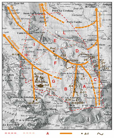
On its way down it collects waters, among others, from Sistema del Canalon de los Desvios (F-18/F-17/F-15) and before emerging on the surface its waters flow through (beneath, along) Cueva del Frieru (K-1) and Cueva del Viento. Other greater caves of this system include Pozu del Porru de los Garapozales (A-3), Sima de los Desvios (F-3) and Sima Profunda. The western and southern boundary of this system seem to be the line going through the Redondo del Conjuarto, Torre de los Traviesos and Torre de la Canal Parda. It is difficult to ascertain if the this line turns at the Tiro de la Llera.
Somewhat shorter, no more than 4 km long, is the system connected with the Río Junjumia. It is relatively little known. Many caves in this area have been not explored to the sump level. The system drains the SW part of the area allotted for exploration. The erosional base lies at altitude 1350-1400 m, while the highest point may reach 2100 m a.s.l., so the maximum vertical range is about 700 m. The system runs from somewhere beneath Jou Sin Tierri towards the NW to the Río Junjumia. In its uppermost course it is supplied, among others, by the already known cave system Sistema Cembavieja (zone of SCP Valencia). Other large caves in this area include, besides those situated in the SCP zone, cave G-13, Red de los Barrastrosas (G-7/G-4/G-5/G-1/G-6), cave SCP 134, Sima de la Porra la Altiquera (H-11), Pozu de la Altiquera. It is difficult to delineate both, the southern and the western boundaries of the system. For this reason it can not be determined where lies the divide between the areas drained by the Río Junjumia and the Río Redemuna.
The shortest, no more than 3 km long, is the system related with the Río La Beyera. It drains possibly a small, northern part of the exploration area. The southern limit of this system can not be precisely delineated, hence it can not be ascertained if the area of its influence reaches behind the line: Sierra Les Robeques - Porru Curelles. The base of erosion of this system lies at altitude ca 1100 m, where the waters surface on Vega Brical, and soon disappear in the active stream cave Pozo Palomberu, to reappear in the Río La Beyera. Accepting that the southernmost parts of the area have elevations close to 1600 m, we get the maximum vertical range of ca 500 m. In the initial course it is supplied, among others, from the east, from Vega El Forcau, by the known cave system Pozu de la Vega El Forcau. The western limit is difficult to draw in the discussed area.
Because of the difficulties in establishing the western boundaries of the systems related to the Río Redemuna and the Río Beyera, one can not exclude that a very narrow, eastern stripe of the exploration area is drain by the system related to the Río Casano. This system, directed to the north, is supplied in its southern part by caves Sistema Jorcada Blanca (F2/F7) and Pozu del Redondo (F20). The waters surface in the valley of the Río Casano in Hoyo La Madre. It is difficult to establish if the system reaches farther south, draining water from beneath Jou de Arenizas and, much lower, from the slopes of the Pico Conjurtau and Porru Cureles. It will appear soon if the concept outlined above is correct. We are entering a new decade and a new century. The fourth decade of exploration in this part of the western massif of the Picos de Europa is before us.
Marek (Stahoo) Jędrzejczak
cały artykuł do ściągnięcia w wersji PDF jes dostepny tutaj:/ you can dowload article from here Picos '2001 (PDF: 2,1MB)